Archive
Wahkeena and Latourell Falls
A few more spectacular falls along the Columbia Gorge! Both Falls have great tourist appeals on the bottom, next to the historic Columbia River Road. They are easy to drive to and easy to see. But both Falls have another personality… take the time to hike up several miles, mostly along the river, and you will see spectacular mountain and river views, with many more falls along the way.
Yes, it takes some energy, as these trails usually involve climbing, up to some 1,300 feet in a mile or two. And yes,there are places where you really have to use some caution, as a miss-step can result in some nasty injuries, even death. But use some care, and you will be rewarded wioth a very pleasant hike and more great scenery.

Tourist view of Wahkeena Falls

But hike along the river a ways....

And you get to the very photogenic Fairy Falls.

Tourist view of Latourell Falls

A slightly closer view

And here is Upper Latourell Falls

John, in an unusual split tree trunk

Not to be outdone, Romola found a strange tree trunk too

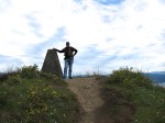
Looking south from Crown Point

And, looking north from Crown Point

Zooming in on Beacon Rock
Denny Creek, WA
Sunday was our last day in Washington, and it was nice and sunny, so we thought a nice hike would be in order. So did half of Seattle! The Denny Creek parking lot was full and overflowing down the road. We went anyway, and it was like walking in a city! However, once we got past the Sliding Rocks, the trail got rough and number of people thinned out considerably.
Denny Creek trail is very scenic, with mountains all around. And waterfalls, including one area where the rock is worn smooth and slick, and it is used for swimming and sliding down the rapids. It is close to Snoqualmie Pass, and about 30 miles from Seattle. This area was very busy!
Once we got past the Sliding Rocks, the trail got very rough and steep. But we were able to get up to Horseshoe Falls, admire it, and return back to the car.

A look up Denny Creek

A very scenic area

Lots of people playing in the water

Romola taking a break

The trail gets steep and very rough

Horseshoe Falls

At the head of Horseshoe Falls
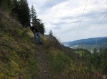
Sauk Mountain hike – spectacular!
Mt. Sauk is a very popular hike in this area. However, when we got close we said “crap!” because ahead of us we could see the very steep climb to the top. With many switchbacks, and a narrow, sometimes soft trail it was sure to be a challenge. And it was, but not as bad as we expected. We did see one guy fall off the trail, but fortunately he was only mildly banged up.
But once on top of all the switchbacks it was magnificent. We had to traverse snowfields, and some rather dangerous sections, but the view was worth it. This has been one of the most spectacular hikes we’ve done in the NorthWest.

Look close, and you can see the trail switchbacking all the way to the to the top.

A closer view of the switchbacks

Halfway up the trail looking back. Skagit River down below.

Catching some local flowers with the scenery.

A view of the trail on the way up

And the trail keeps climbing....

Looking back the way we came. Parking lot visible too.

Once over the top the rst of the hike is visible

Romola, traversing one of the snow fields

What a view.....

The trail goes that-a-way!

Another view from the top. Romola's blue hat is visible too!

The views just don't stop coming.

On the way back we noticed Mt. Baker peeking around a corner.

And let's not forget all the wildflowers growing in profusion
Alger Alp hike, WA
The Alger Alp hike is all on abandoned logging road, so it is an easy walk, terrain wise. But it is all uphill to the summit, just over 2 miles of uphill. It is amazing to think that at one time heavily laden logging trucks came down these roads!
Unfortunately, the weather never cleared, so the expected views were severely limited. Nevertheless, we had a nice hike, d picked up a few geocaches along the way.

Start of the hike, with the destination (top of the hill) visible

Foxgloves provide some color alongside the trail

Half way up, still a ways to go to the top

We actually beat this local resident to the top

View from the top, limited by clouds

A view on the way back

We found a cache by the side of this creek
Angel’s Rest, Columbia Gorge
The weather has been so bad the last month we haven’t hiked much. So with finally a nice day we drove the 30 miles to get to the Angel’s Rest trail. It’s amazing how quickly you can get out of shape! Now the Angel’s Rest hike is 2.3 miles long, but it’s all uphill — all of it. It climbs some 1,500 feet in that distance. Sore quads by the time we got to the top!
Along the way, there wer waterfalls (there are always waterfalls here!) but no scenic pictures, as the vegetation is in full bloom and much of the falls are obscured. But the wildflowers were great! Once at the top the views are spectacular. Not much mountain view, but a lot of the Gorge itself. A great hike!
And don’t believe that since it is all downhill on the way back it’s all easy. By the time we got back to the car we truly felt we deserved a microbrew and pizza, which is conveniently located just down the road from our RV.

Starting point for several hiking trails

Better watch your step!

One of the few waterfalls wich were visible

Purple flowers

Hey! A wild rose!

A purple iris

1 1/2 miles in, and the destination is in view

Posing at the top

The view we came for

Coming down wasn't all easy, either
A steep hike on Beacon Rock
In 1806 Lewis and Clark discovered a huge rock outcropping on the Columbia River,which they named Beacon Rock. It is almost 900 feet tall and 400 feet in diameter. In the early 1900’s there was talk about blowing it up to make crushed rock for other projects. Fortunately, this did not happen.
In 1915, the property was bought (for $1) by Henry Biddle, who wanted to build a path to the top. This he did, finishing the tortuous trail in 1918. The same path still exists today, and is now a State Park. We hiked up it today.
An interesting note, he offered the park to the State of Washington in 1935, with the provision it would remain a free park in perpetuity. Washington turned him down, so he offered it to Oregon. They did wanted, and annex the property, but as soon as Washington heard this they changed their minds. It is now a Washington Park.
-
- Check out the trail….
-

- Romola on the trail up
-
- A view downriver
-

- Looking to the north
-

- Looking up to the trail
-
- A lot of work went into this trail!
-
- A view upriver (Bonneville dam)
-
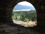
- A “beauty shot” through a stone portal
-
- At the start of the trail
-
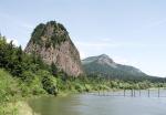
- Beacon Rock, from the river
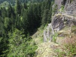
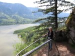
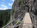
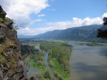
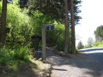
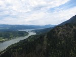
Wauna Point hike
Another hike that starts at Eagle Creek trailhead takes you to the top of Wauna Point. This is a hike about 4 miles long, and gains about 1,100 feet in altitude. Along the way, you can see the Columbia Gorge, and from the top you get an excellent view of the Bonneville dam and Cascade Locks.
-
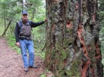
- There are some very big trees up here
-
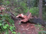
- This fell shortly before we got here. Glad it wasn’t later
-
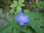
- Flowers are starting to grow here too
-
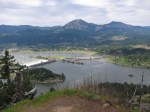
- A view of Bonneville Dam and the locks
-
- Getting close to the top
-
- At the monument at very top
-
- A view to the East
-
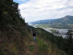
- Enjoying the hike back
-
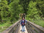
- And over Eagle Creek suspension bridge
Eagle Creek to Punchbowl Falls
This hike is considered one of the most scenic in the NorthWest. Starting about 40 miles from Portland, it follows Eagle Creek along many falls and scenic lookouts. If you keep going, you will end up in Mexico, as it ties into the Pacific Crest Trail. We hiked the first 5 miles today and had a great hike.
There is so much to see and to do in the NorthWest! We look forward to many other similar hikes while we are in the Portland area.

Start of the trail, alongside Eagle Creek

Some of the trail is scenic, but easy, walking....

... and some require waterproof boots ....

... and some require a careful step.

Metlako Falls, on the way to the Punchbowl

Finally, a top down view of Punchbowl Falls

A dramatic view from the bottom of the Falls

Spring flowers, like this Shooting Star, are coming out in the spring
Hood River Mountain Hike
Did our first hike of the year, and had a great time. This area of the country has some beautiful (and challenging!) hikes! We found this hike on the Portland Hikers website, and it looks like there will be many more to come.
Our hike today was wonderful. The climb up was a bit of a stress, our flat land legs just aren’t used to it — yet. But we look forward to many more hikes to come.

The first mile is uphill, through the trees

Looking north - that's Mt. Adams with Mt. Rainier (left) peeking over the hills.

And here's Mt. Hood, viewed from Hood River Mountain summit

I call this image "Black and White, in color"

Flowers are just starting to appear

Multnomah Falls

Fruit orchards are all over the place in this area
Glacier: Avalanche Lake
A very popular hike is the Avalanche Trail to Avalanche Lake. It is a nice hike, ending with a stunning vista at the Lake. Along the way, you are rewarded with waterfalls, forests, and some wild animals. Fortunately, we missed the black bear that had visited this trail a short while before we got there.
This was a ranger led hike, with the ranger giving us very interesting information about the geology, the history, and the flora and fauna of the area.

Avalanche Gorge, near the start of the hike

The water carves a unique pattern in the rocks

A view along the trail

This knot hole caught my attention

Cow parsnips, a favorite food of the local bears

Oops, glad we missed the bear that dropped this!

Aaaaww.....

And finally, Avalanche Lake.
No matter how you take this picture, no matter what camera you use, there is no way to capture the beauty without seeing it in person. Glacier: we recommend this area in general, and this hike in particular, to everyone.
