Alaska: Skagway
In 1896 gold was discovered in the Canadian Yukon, causing a major prospector rush. One of the more popular ways to get there was to take a boat from Seattle to Skagway, then hike the 550 miles to the gold fields. The first 40 miles were treacherous, going over White Pass, followed by a long and dangerous hike. So many prospectors didn’t make it that the North West Mounted Police manned a border crossing and demanded every prospector carry one ton (!) of supplies. This required many prospectors to hike the Pass 30 or 40 times carrying goods just to be allowed into Canada!
The city of Skagway was a booming place with bars, parlors, businesses, con men (such as “Soapy” Smith), and loose women. Some very fantastic schemes were sold to unsuspecting prospectors (like the guy who sold “specially trained gophers that would gather gold for you”)! Eventually a narrow gauge railroad was built, requiring some 450 tons of dynamite just to make the roadway. But by the time it was finished the gold rush had dwindled to almost nothing. Skagway declined and was pretty well dormant for decades.
During World War II the US leased the railroad in its effort to protect against Japanese attacks. As a result, many improvements were made. Narrow gauge locomotives and rolling stock arrived from around the country. After WWII, the railroad again was dormant, parts going into receivership.
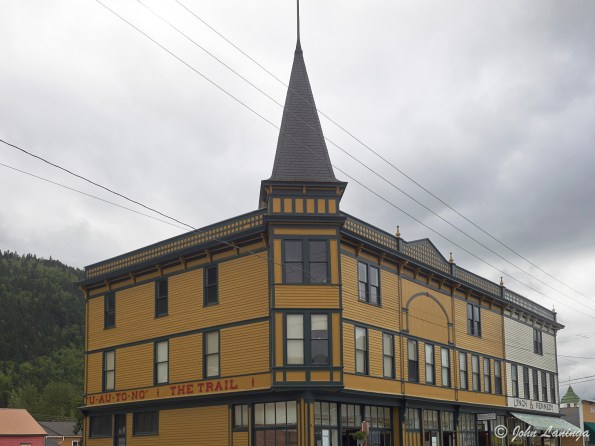
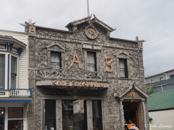
Then tourists arrived, coming in huge cruise ships. The town has been rebuilt and still has many original buildings. The White Pass and Yukon Railway also was purchased and rebuilt into a major tourist destination.
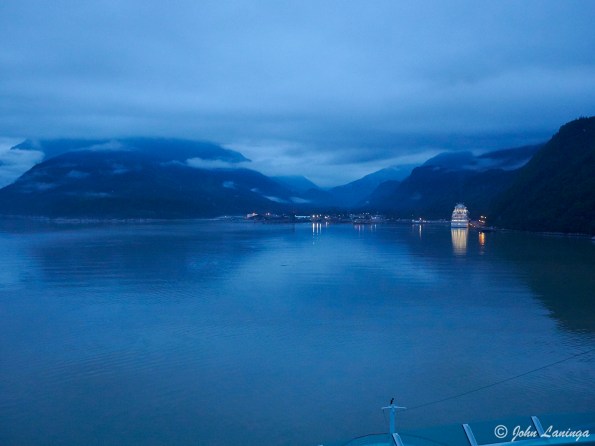
Early morning arrival in Skagway

Red Onion Saloon
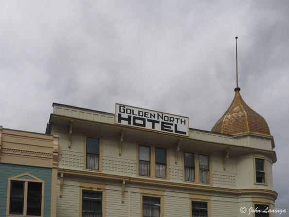
Golden North Hotel
Skagway Rail Station
Now a museum
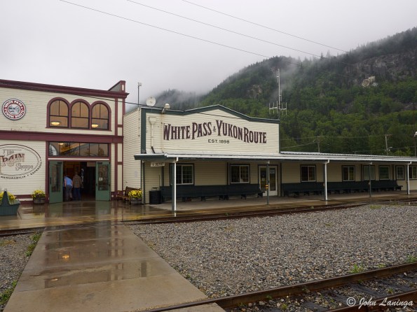
The WP&YR Depot
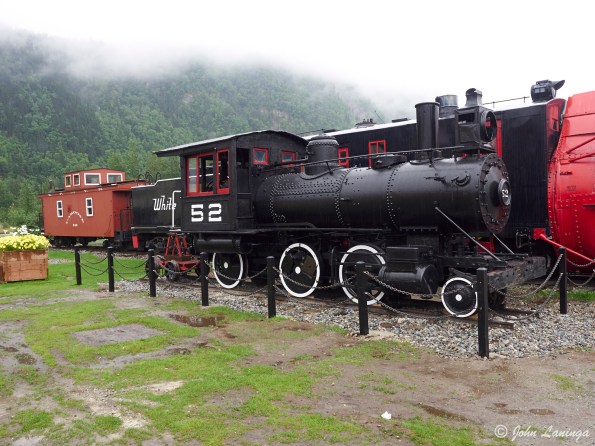
One of the early steam locomotives
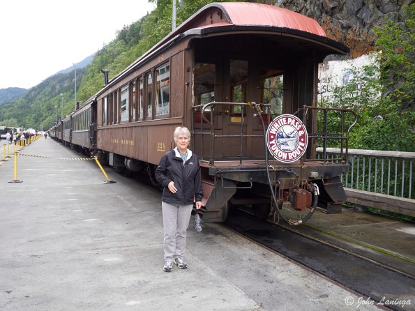
Getting ready to board the train
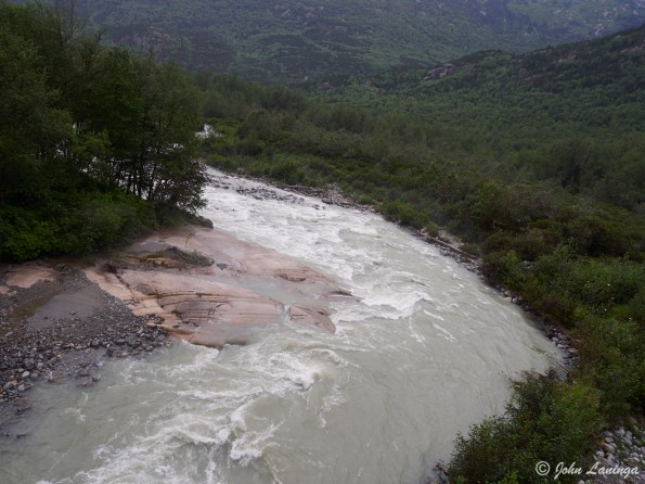
A look down from the train
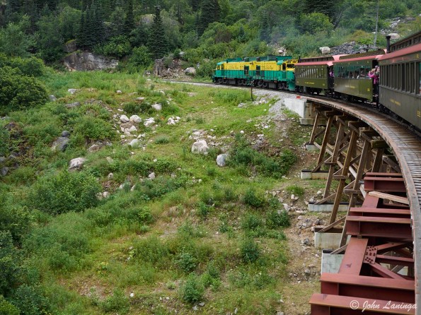
Engine, crossing a trestle bridge
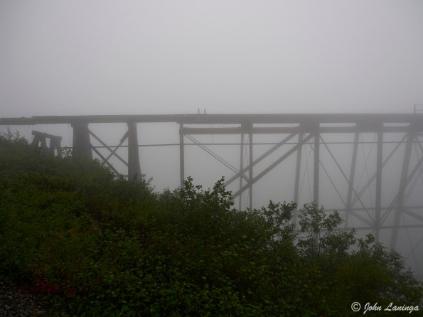
A ghostly view of the Cantilever Steel bridge (no longer used)
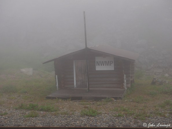
The NWMP station at the top of the pass
Alaska: Ketchikan
Ketchikan bills itself as “the Salmon Capital of the World”. And indeed we enjoyed salmon fish and chips, as well as sending some salmon home. It is also known as one of the wettest cities in the USA (rainfall in excess of 18 feet in one year). True to its reputation, it rained on our way up but we were treated to a exceptional sunny day on the way back.
The population of Ketchikan is around 8,000. The day we were there there were 4 cruise ships, so we had around 10,000 tourists in town. Talk about crowds…. But we all got a chance to see the salmon going upstream to spawn, look at the largest totem park in Alaska, and visit historical Creek Street, which catered to lonely lumbermen and miners in the 1890’s.

Arrival in the rain

In case you wondered where we were…

The theme certainly includes whales

Salmon statue

Fish ladder

Historical Creek Street

Spawning fish

The fate of the salmon after spawning

Just had to buy some salmon

Steep hills around the city

Before TV, entertainment had a distinctly manly theme
Sauk Mountain hike
The Sauk Mountain hike is recognized as one of the most scenic in the NorthWest. But you have to endure a rough ride to get to the trail head, followed by a strenuous climb. But this time of the year the wild flowers are in bloom, the mountains still have snow caps, and the scenery is just gorgeous.
The “road” to the trail head is gravel washboard with huge potholes. It is narrow, has big drop-offs, and many switchbacks. Fortunately, we didn’t meet much traffic either way. And when you see the trail itself you do a bit of a double take… so steep! But watch your footing… the trail is narrow and the way down long!
The hike isn’t terribly long at 4.2 miles, but it gains 1,200 feet in the first 2 miles. But it is doable (even for us old farts) and the views from the top as well as along the trail are spectacular. On the way up there is a closeup view of Mount Baker, and at the top Mount Rainer is visible. Visibility was somewhat reduced from the forest fires but still quite amazing.

Check the “road” on the GPS….

Can you spot the trail, heading all the way to the top?

A really cute out house

View from the top

From half way up. See our car far below?

A view of Mt. Baker

Wild flower

Wild thistle

Wildflower

Some of the scenery along the trail

Heading back

Snow!

Romola at the top

More snow

Sauk Lake

Looking north

Looking south
1867 Baseball game
At Fort Vancouver, WA there is an interesting re-creation of an 1867 baseball game. It is based on an documented game between the Portland Baseball Club and the Vancouver Occidentals. Teams are in full authentic uniforms, and many spectators are also in period costumes.
The game itself is played in accordance with 1867 rules. That means, no gloves, fly balls may be caught on the first bounce, pitcher throws underhand to the batter and many more differences from today’s game. Here are some images.

The timekeeper arrives

More arrivals

Fans arriving

Mother and child

The scoreboard is set up

Warming up

Team strategy session

The cannon starts the game

It’s a hit!
Last canon firing
One of my more interesting duties as Fort Vancouver volunteer is demo’ing black powder. Last weekend, we did rifle and canon firing. My duties were firing the canon. Pictures below.
The canon is an 1841 Mountain Howitzer, very popular in the day as it was effective, light, and transportable. It could be broken down and carried on two horses or mules. It was optimized for firing explosive shells as well as spherical case and canister. Its range was about 1,000 yards. It was popular in the Civil War, especially in the west because it did not require roads to transport.

The 1841 Mountain Howitzer

Ready for action

Cleaning the barrel

Waiting for the charge to be delivered

Ready for the Fire command

FIRE!

And from the other side….
Silver Falls State Park, OR
Thanks to an internet acquaintance, we learned about the Silver Falls State Park. This park has a 9 mile hiking trail, with 10 major waterfalls along the route. Known as the Trail of Ten Falls, it was too good to pass up, especially since we’ve hiked most all the waterfall hikes along the Columbia Gorge. It was a beautiful day, so the timing was perfect.
Right away, we were impressed by the falls we saw. The falls tumble over basalt lava flows, and erode the softer ground underneath. This makes for some excellent opportunities to walk behind the falls for a truly unique perspective. We opted for the slightly shorter route (6 miles) which gave us most of the major falls. Really a beautiful park, and highly recommended (although we hear that on the weekends it gets very crowded). Here are a few highlights; more images in our Flickr album (see blog roll).

South Falls, 177 ft.

South Falls from behind

A different view of South Falls from behind

Middle North Falls, 106 ft.

Top of Middle North Falls

Bottom part of Middle North Falls

Lower South Falls, 93 ft.

Winter Falls, 134 ft.
Horsetail Falls, Columbia Gorge
Took advantage of the great weather to take a hike up to Horsetail Falls. A nice hike, with three falls. Unfortunately, we couldn’t go all the way to Triple Falls as a landslide has blocked the hiking trail. But it was a nice hike, and the views of the Gorge are spectacular.

Lower Horsetail Falls

Middle Horsetail Falls

Underneath Middle Horsetail Falls

A view of the falls from behind

Main view of Middle Horsetail Falls

Upper Horsetail Falls

This was a little disconcerting, it was a long way down

And this kept us from getting to Triple Falls

A view of the original road tunnel

A view of the Gorge, looking east
Fireworks at Fort Vancouver
One of the benefits of volunteering at Fort Vancouver is being able to get a ringside seat for the 4th of July fireworks. No small thing; the annual Fort Vancouver fireworks are rated in the top 10 in the country.
This year, we were asked to also assist in the firewatch, which means outside the fort walls, right near the launch point. In fact, we had to stay clear of the road for fire trucks, if they were needed. What surprised me how much fire was on the ground; all that fireworks and dry grass makes for a good bonfire! But nothing was out of control, and they were quickly suppressed.
We did get a spectacular view of the fireworks. And yes, we were so close we had to wear ear plugs.

Spectacular bursts

Going up!

Truly spectacular

Multiple starbursts

Starburst

Quite a few fires on the ground
Oregon coast, Part 2
After we left Florence we went to Lincoln City where we enjoyed the scenery and a nice waterfall hike. And we had some of the best Dungeness crab we’ve ever had at the Casino. To make up for it, we had a longish (and muddy) hike on Cape Lookout.
From Lincoln City we went to Seaside where we stayed at a Thousand Trails park. The scenery around here is just fantastic, as is the hiking. And of course, a visit to Astoria included the Maritime Museum (very interesting!) and of course Bowpickers Fish and Chips.
We hiked in Canon Beach, but the trails were too muddy so we turned back. But again the scenery made it wort its while. We did get a view of Tillamook Rock Lighthouse, also known as Terrible Tilly because of the really bad weather in this area. It was decommissioned in 1957 and is now privately owned… and used as a columbarian (place to store cremated remains).
Since we had so much rain, we went to Fort Stevens where the main trails were paved, much easier to navigate. But Fort Stevens was fascinating, first built during the Civil War and used during WWI and WWII. It was fired on by a Japanese submarine in 1942, marking the only time US soil had a direct attack.

Drift Creek Falls

Suspension Bridge over Drift Creek Falls

A bee hard at work

Looking SouthEast from Cape Lookout

Looking NorthEast from Cape Lookout

A little rough, a little muddy

Surfing near Canon City

One of the batteries at Fort Stevens

A view over the Fort Stevens bulkhead

Part of Fort Stevens, built during the Civil War

Standing by the Peter Iredale, shipwrecked in 1906

Very little left of the major cannery fire near Astoria

Tillamook Rock Lighthouse, aka “Terrible Tilly”

Posing near Canon Beach

Surf rolling in near Canon Beach

From the Acola Trail, near Canon beach

Haystack Rock, Canon Beach
Oregon coast, Part 1
Our first stay on the coast was in Florence. It is near the Oregon Sand Dunes, as well as the mid Oregon coast. Also close by are the sea lion caves, Heceta Head lighthouse, and Cape Perpetua. And, not to forget, the Spouting Horn.
The Oregon Dunes is the largest body of sand in the US, almost 47 miles long and 2 1/2 wide. It is both a natural preservation area and a much used recreation area for dune buggies. We learned that hiking in sand is not as easy as on dry land!
The Heceta Head Lighthouse was built in 1894 and is still in use today. The light is visible from 24 mikes out at sea, making it the most visible lighthouse on the west coast. It is a favorite subject of photographers.
Cape Perpetua is a prominent hill, with some of the best coastal views in Oregon. In 1933 the CCC built an observatory here to watch for enemy ships. It was quite a hike from sea level to it’s 800 foot observation point! Nearby is Devils Churn, Thor’s Well, and Spouting Horn .. all quite a sight when the tide is in.

Heceta Head lighthouse

Romola on the beach neat Heceta Head

Farm market in Eugene

More farm market in Eugene

Beautiful purple colors

Darlingtonia California, an insect eating plant

Cape Perpetua, quite a climb to the top!

Looking south from Cape Pepetua

Observatory on Cape Perpetua

Looking north from Cape Perpetua

Romola at the observatory

Spouting Horn

Sand buggies on a climb

Motorcycle vs. sand buggy

Distan view of Heceta Head lighthouse
