Archive
Fantasy Canyon, UT
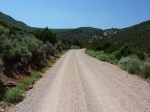
While Bryce Canyon is the best known for its unique formation, Fantasy Canyon has to have the strangest formations of all. It is much smaller (only several acres) and it is very remote, so it only sees some 5,000 visitors a year. It isn’t that its so far (only about 45 miles from Vernal, UT) but the last part of the drive is on oil company roads… rough and dusty. But we found the trip worth the effort. Take a look:

Most all the formations are named; this one is "Flying Witch"

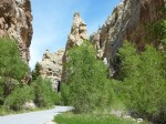
Strange formations all along the 1/2 mile hike

A different angle shows different details

These formations are quite fragile and won't last forever

Deeper in the canyon reveals ever more formations

And more stuff....

I think this was "Rabbit Ears"
Harpers Corner and Echo Park
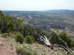
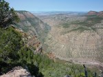
Harpers Corner is located in the Colorado side of Dinosaur National Monument. It is a very scenic drive, worth the time to get there. There is a previous blog about this drive; do a search on “Harpers” to find it. Once there you will find a 1 mile hike that brings you over a promontory overlooking the confluence of the Yampa and Green River. You are about 1,700 feet above the rivers, and there is a great viewpoint.
Once we left the overlook, we drove to Echo Park. The road there is 13 miles of very steep, switchbacks, and rough surface that will get your attention. In fact, if it is raining the road is impassable. Along the way you pass the now unused Chew ranch, more Petroglyphs, and Whisper cae. The cave is rather unique in that it does not appear to have any openings yet there is a breeze blowing out of the cave… and it is some 20 degrees cooler. Very interesting!
We made it back up the Echo Park road just before we ran out of gas so we had yet another great day in Dinosaur National Monument. Remember, you can click on an image twice to get a larger image if you want to see more detail.
-
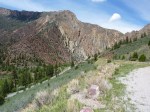
- The road back. You can see the switchbacks up ahead
-
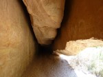
- Inside Whisper Cave. Hope the ceiling doesn’t come down….
-
- Whisper Cave, lots of cool air coming out of the cave entrance
-
- Steamboat Rock, behind the cliff
-
- Steamboat Rock. Here the Yampa and Green rivers meet.
-
- An old hut. Wonder who worked here?
-
- Inside the “motorhome”- bed above the loft
-
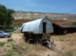
- What’s this, an antique horse driven motor home?
-

- And don’t even think about it if it wet!
-
- The “Mittens”, a very strange uplift from tetonic plate movement
-
- A good view of Steamboat Rock from Harpers Corner.
-

- Another view of the Green river
-
- The Green and Yampa rivers, now flowing as one
-
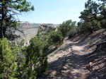
- The way to the promontory takes you along a ridge with serious dropoffs on either side. The promontory is in the distance.
-
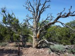
- Trees, even dead ones, take on interesting shapes in the desert climate
Summer heat and “snow”
There are huge cottonwood trees here in Dinosaur Monument. Many of them are right by our campground. And, when the wind blows, it looks like a snowstorm. Really! Here are some pictures.

A view of some of the trees next to our motor home.

A closer look at the cotton "snow" clusters

The cotton looks like snow on the ground
Viewing the cosmos
Most National Parks have educational programs that are free and interesting. One thing about Dinosaur NM is the lack of light pollution, especially the eastern sky where the nightime “dark” is as good or better than any other location in the US. So, the Park puts on a “Viewing the Cosmos” program, which has been well attended.
The program is put on by Niles and Bobby Allen, who are volunteers and put these shows on at different locations. Niles brought his big scope (see picture) which is quite amazing. Also, the Park provides several high quality night scopes to add additional capability.
We were able to see many objects in detail, including the moon, mars, Venus, and Saturn. On Saturn you could even see the rings and two of its moons through the big scope.
In addition to viewing, Niles did an interesting presentation on the cosmos, pointing out the various stars, constellations, and planets. Some people decided to lay on the ground for easier viewing; it was interesting to see about 20 people lying on the ground, looking up! A very interesting (and free) program put on by the parks!

Dusk, time to set up the various telescopes. Framework of the big scope visible as well.

Claudia, our always smiling and helpful Park Ranger

The big 'scope, almost ready for viewing, Niles doing the set up

Tried to take a hand held picture through the scope, not well centered but you get the idea. This was the mid sized 'scope.
Flaming Gorge
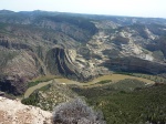
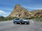
Our day trip today took us to Flaming Gorge, about 60 miles from our campground. This was truly awesome, it ranks as the best day trip ever. Scenery was stupendous. I’ll post an album of highlights, but there is no way to capture the grandeur of these mountains and gorges on a digital image.
The first images show Flaming Gorge highlights, then there are images from the Geological Scenic Byway — a rather small, heavily potholed road that had scenery beyond compare.
-
- Check out the many rock formations and layers that we came through
-
- The “Tower”.
-
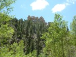
- The rock outcroppings are amazing
-
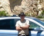
- OK, here’s the hat…
-
- Modeling my new hat in front of Navajo Rock
-
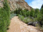
- High temps mean big snow melts resulting in heavy water flows.
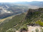
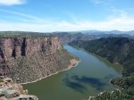
-
- Looking north into the valley
-
- And, a view to the south
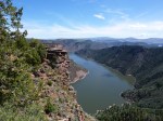
-
- Another gorge view, this time to the west
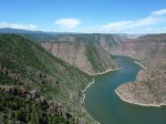
-
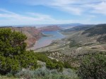
- A textbook view of Flaming Gorge, looking north
-
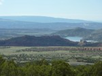
- Looking back where we came from.
Hiking at night
One of the park Rangers (Amy) held a “moonlight walk” to show that you did not need daylight, or flashlights, to hike. So we did a 2 1/2 mile loop (Desert Voices) just to experience this. It was interesting to see the different plants that open at night, the different animals, and the different birds (we also saw bats). Unfortunately, it was cloudy and we finished the night in serious dark conditions.
Don’t think I’ll give up my day hikes, but it was fun, and educational.

Amy explaining, John grinning, Josh and Romola paying attention before the start

Half way into the hike, setting sun, and darkness descends
Hiking, rafting and history
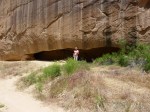
About a 1/2 hour drive from our campsite is McKee Springs, yet another great petroglyph (Fremont indian rock etching) site. Obviously, the Fremont Indians were quite the artists as you can find lots and lots of artwork. So off we went to explore this, and some other sites in the area. Our new car got a great introduction to off pavement driving!

Most of the road to McKee Springs is gravel

But once there you will find some of excellent Fremont artwork

A second panel of artwork

But the Petroglyphs had to share top billing with a spectacular flowering cactus
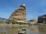
A short ways down the road from McKee Springs is Rainbow Park. This is a smallish campsite and is used primarily by rafters, who put in here for a day trip down the Green River. It may look peaceful here, but there are class 3 and 4 rapids just around the bend…

A great early morning view. But don't let the image fool you, that water is moving, and fast. That surface is deceiving!

Rafters, getting ready for their adventure

And they're on the way

Once around the bend in the distance they will be in some major rapids
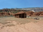
About 5 miles further down the road is the now abandoned Ruple Ranch. This area was homesteaded in the mid 1800’s by the Ruple family, who eventually sold this property to the National Park Service where it is now part of Dinosaur National Monument. This is the back side of Split Mountain, where we are camped.
The road in ends up as a rutted wagon trail, and although we have 4 wheel drive we sure didn’t have the clearance to go much further so we parked and walked the last mile to the trail. It is an easy trail, although very rough as it isn’t used much and most of it is in a sandy wash literred with rocks.

This is as far as we got. Yes, we have 4 wheel drive, but not the required high clearance needed to traverse this old farm road.

Some of the old (but not original) buildings of Ruple Ranch

Once out of the car we hiked up the wash.

A really strange desert plant. Only saw one of these. The tall "stem" was way out of proportion to the leaves below.
All in all an interesting day. Some nice hiking, some history, some scenery, and great weather.
Our campsite at Dinosaur Nat’l Monument
We love our lifestyle, full timing in our Monaco motor home. Here we are, parked at Dinosaur National Monument. The Green River (famous for wild raft rides) passes right behind us, and Split Mountain is a little farther on. Can’t get much better than this…

Retirement beats working hands down!
A most pleasant day
Today we hiked Sounds of Silence again. So much to see! New flowers are blooming, bringing a new color cast to the desert. Want to know why it is called Sound of Silence? Once you get around some of the rocks there is no sound except local animals. In fact, the silence is so great that it has been measured: at less then a quiet sound room for music recording! Some pictures:

The path through the red wash, uphill to the plateau

A view from the plateau

A splash of white, in the middle of the desert

Coming down from the plateau requires walking down slick rock, OK when it is dry but really slick if wet...

Somewhere in there is the "path" we took back down. A good test of nerves, and hiking shoe traction. Slick rock photo taken at the top
Jones Hole fish hatchery
About 10 miles as the crow flies north of our campsite (and 40 miles as the car drives) there is a beautiful canyon with a terrific hike along a trout filled river. It is also the location of one of the 370 or so fish hatcheries the NPS uses to stock fish for various lakes and rivers. Here, in Jones Hole, they raise trout. So we decided to take the long drive down, and as long as we’re there, do the 6 miles hike. We’re glad we did.

The road down to Jones Hole. Better check your brakes!

A few of the fish stock tanks.

Some trout beginning their trip to another river

Part of the trail is shaded and and popular with fly fishermen

You just can't get over the enormous and beautiful scenery.

Along the way are some excellent examples of Indian pictographs (rock paintings), about 1,000 years old

Waterfalls add another scenic element

A moving road block on the way back. These guys have no respect for right of way!
